
A project funded by the Leverhulme Trust.
(Featured image courtesy of NOAA Digital Coast.)
We hypothesise that scaling laws for flood deposits in built environments differ systematically from those for flood deposits in non-built environments.
Population and land-use pressures on river and coastal floodplains means that flood events deposit large volumes of sediment and debris in built environments. These “unnatural” flood deposits are ubiquitous, delay emergency response, and are costly to clean up. We aim to predict how spatial characteristics of the built environment control the shape, scale, movement, and distribution of flood deposits. We will measure and model flood deposits in built and non-built environments to quantify and explain their differences. This project is a formative step in transdisciplinary research into how natural phenomena interact with and impact built environments.
TEAM


Dr Evan Goldstein – Co-investigator; Dr Hannah Williams – Research Fellow; Luke Taylor – PhD student
GALLERY


Tweets from the keystone experiment at the Hull’s Total Environment Simulator (TES):
RELATED PUBLICATIONS
Lazarus ED, Williams HE, Goldstein EB (2022) Volume estimation from planform characteristics of washover morphology. Geophysical Research Letters 49, e2022GL100098 https://doi.org/10.1029/2022GL100098
Aldabet S, Goldstein EB, Lazarus ED (2022) Thresholds in road network functioning on US Atlantic and Gulf barrier islands. Earth’s Future, 10, e2021EF002581 https://doi.org/10.1029/2021EF002581
Lazarus ED (2022) A conceptual beachhead: “Beaches and dunes of human-altered coasts” by Karl F. Nordstrom (1994). Progress in Physical Geography 46(3), 481–490 https://doi.org/10.1177/03091333211054679
Lazarus ED (2022) The disaster trap: Cyclones, tourism, colonial legacies, and the systemic feedbacks exacerbating disaster risk. Transactions of the Institute of British Geographers, 47, 577–588 https://doi.org/10.1111/tran.12516
Goldstein EB, Buscombe D, Lazarus ED, Mohanty SD, Rafique SN, Anarde KA, et al. (2021) Labeling poststorm coastal imagery for machine learning: Measurement of interrater agreement. Earth and Space Science, 8(9), e2021EA001896 https://doi.org/10.1029/2021EA001896
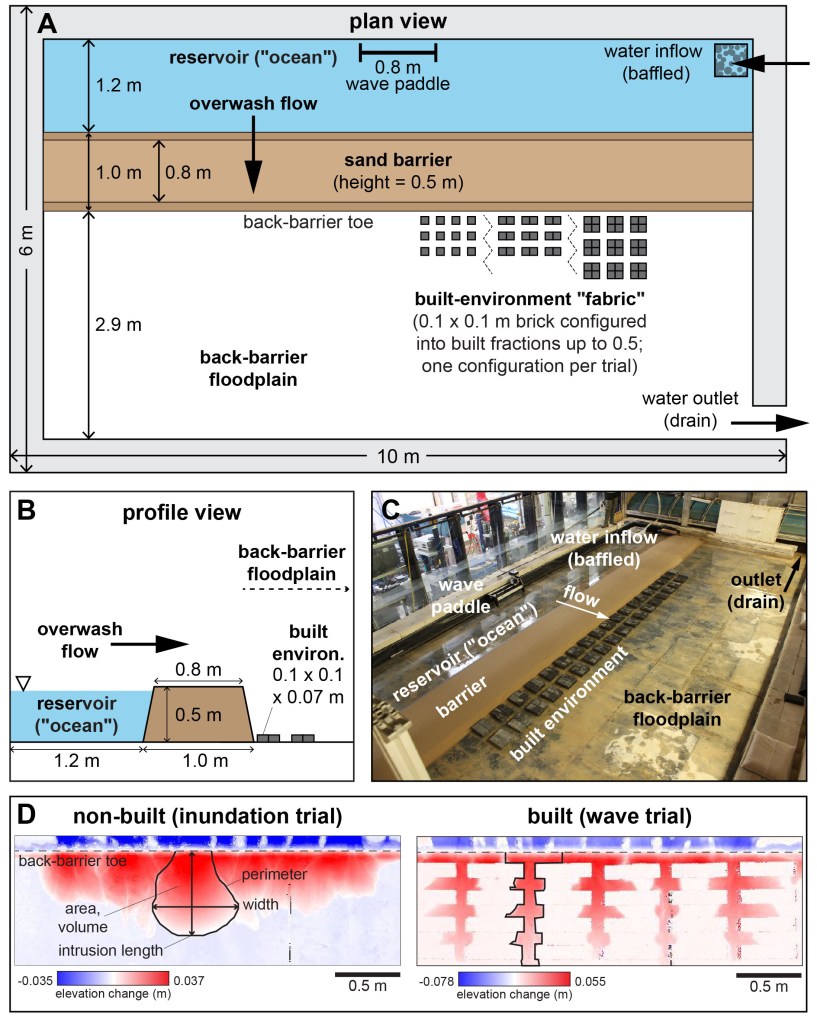
Lazarus ED, Goldstein EB, Taylor LA, Williams HE (2021) Comparing patterns of hurricane washover into built and unbuilt environments. Earth’s Future, 9(3) e2020EF001818 https://doi.org/10.1029/2020EF001818
Lazarus ED, Goldstein EB (2019) Is there a bulldozer in your model? Journal of Geophysical Research Earth Surface 124, 696–699 https://doi.org/10.1029/2018JF004957
DATA & CODE
Williams HE, Lazarus ED, Goldstein EB (2022) Data and morphometric results from a physical experiment simulating washover deposition [Data set], Zenodo https://doi.org/10.5281/zenodo.7075282
Lazarus ED, Williams HE, Goldstein EB (2022) Washover morphometry: lidar-derived and reported in literature [Data set], Zenodo https://doi.org/10.5281/zenodo.7075323
Lazarus ED, Williams HE, Goldstein EB (2022) Code for “Volume estimation from planform characteristics of washover morphology” , Zenodo https://doi.org/10.5281/zenodo.6641396
Aldabet S, Goldstein EB, Lazarus ED (2022) Dataset for "Thresholds in road network functioning on US Atlantic and Gulf barrier islands" [Data set], Zenodo https://doi.org/10.5281/zenodo.6354814
Aldabet S, Goldstein EB, Lazarus ED (2022) Code for "Thresholds in road network functioning on US Atlantic and Gulf barrier islands" (v1.0.0) , Zenodo https://doi.org/10.5281/zenodo.6354835
Taylor L, Williams H, Goldstein E, Lazarus E (2021) Data for "Comparing patterns of hurricane washover into built and unbuilt environments" [Data set], figshare https://doi.org/10.6084/m9.figshare.12608828.v1
Goldstein E, Lazarus E, Beuzen T, Williams H, Limber P, Cohn N, et al. (2020) Labels for Hurricane Florence (2018) Emergency Response Imagery from NOAA [Data set], figshare https://doi.org/10.6084/m9.figshare.11604192.v1
